Ithassa Map: Difference between revisions
Jump to navigation
Jump to search
Ethanbrice (talk | contribs) mNo edit summary |
Ethanbrice (talk | contribs) mNo edit summary |
||
| Line 17: | Line 17: | ||
* '''WC''' ''[[Wheeler Colony]]'' - An old mining colony in the Deadwood System. | * '''WC''' ''[[Wheeler Colony]]'' - An old mining colony in the Deadwood System. | ||
* [[Image:IthassaRegionMap.JPG|Ithassa Region Map]] | * [[Image:IthassaRegionMap.JPG|250px|thumb|Ithassa Region Map]] | ||
------------ | ------------ | ||
[[Image:Ithassa_map_AUGUST.jpg]] | [[Image:Ithassa_map_AUGUST.jpg]] | ||
[[Category:Ithassa Region|*]] | [[Category:Ithassa Region|*]] | ||
Revision as of 09:26, 25 May 2009

|
| Ithassa Region (Map, Stellar Cartography) |
|---|
| Major Neighboring Powers |
| Governments & Alliances |
|
| Known Races |
| Starfleet Presence |
|
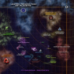
Legend
- 1K -One Kingdome - 13 systems populated by the multi limbed Constellationites.
- IC -Igloo Cluster - 93 compact systems and home to the Grendellai.
- Aurona Sector - A dangerous area of the Ithassa region with several nebula and uniformly poor communications and sensors.
- 3A9 - A system with a M class world populated by a Tzenkethi research facility.
- T8A - is an uninhabited tropical paradise according to unmanned probes. On 238404.30 exploration of the planet was begun by two Starfleet Security Officers from the USS Triumphant - Kassa Quay and Thompson Kirby. The explorers renamed the planet Planeta del Amor
- WC Wheeler Colony - An old mining colony in the Deadwood System.
